Google Maps is the most advanced maps in the world. The company is constantly developing them and has just introduced a new function to help them take care of the environment.
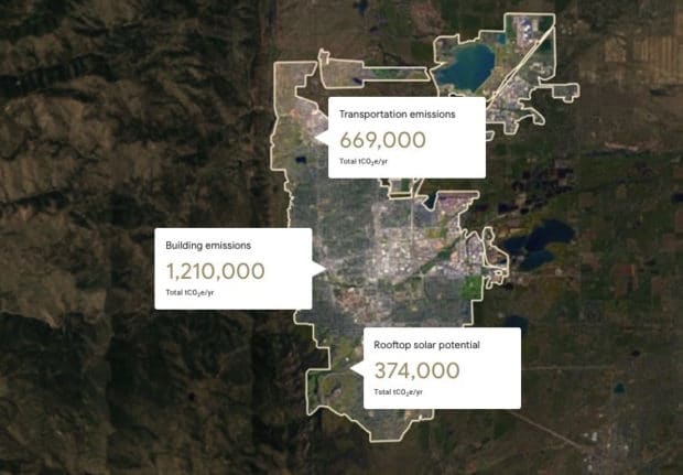
The company used car traffic data associated with city photos and other parameters to determine the city’s carbon footprint. The tool is called Environmental Insights Explorer (EIE) and it has been launched in beta. It can distinguish between houses and businesses and, thanks to traffic data, can determine the emissions related to the city’s transport habits.
Also read: Printing metal just got easier with Desktop Metal
Cities that will benefit from Google’s results will be able to make various changes to reduce their carbon footprint. Examples include greater incentives to install solar panels in certain neighborhoods, or the introduction of more public transport.
For now, EIE shows data for only a few cities in the US, Canada and Australia. You can check the results shown by the tool at this link.
Source: https://bgr.com/
Related posts:
 Google introduces new features. They are designed to help reduce your carbon footprint
  Google Maps – without permission to download data, there will be no navigation
  Google Maps will get a new widget that will make navigation easier
  Google Maps will get a feature that will allow you to avoid pre-Christmas crowds
  Google is working on a technology that improves image sharpness
  Google ban cryptocurrency related ads